During climate week meetings in September, 2014, UNISDR announced that CISR’s new Coastal Defense application, which is part of TNC’s Coastal Resilience 2.0 web-based mapping platform seen here, won the award for best Professional and Scientific App in the Global Disaster Resilience App Challenge. The software development challenge was part of the UNISDR campaign “Making Cities Resilient: My City is Getting Ready” as support to the UN secretary–general's efforts to accelerate actions that build resilience to climate change. CISR was responsible for designing and developing the enterprise version of the app that received the award.
The award was announced during the United Nations Climate Summit on September 23, 2014. The White House Council on Environmental Quality followed with a memo release targeting Coastal Resilience on October 8, 2014 that mentions the award-winning application.
Coastal Resilience 2.0 is a decision support system that provides communities, planners, businesses and officials a step-wise process to guide decisions to reduce the ecological and socio-economic risks of coastal hazards. A core feature of the system are purpose built plugins, or “mini apps”, that integrate coastal hazards with social, ecological, economic and coastal engineering to identify solutions.
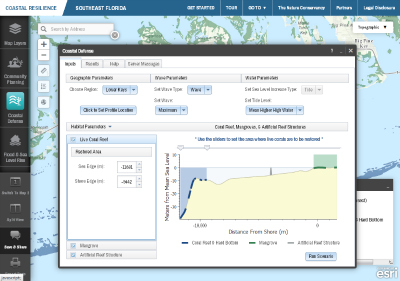
The Coastal Defense plugin developed by CISR serves as the most popular and in-demand app. The plugin quantifies how natural habitats, including oyster and coral reefs, marshes, mangroves, beach dunes, and seagrass beds, protect coastal areas by decreasing wave-induced erosion and inundation. It uses standard engineering techniques to calculate the reduction of wave height and wave energy in the presences of these habitats. The coastal protection model for the app comes from the Natural Capital Project’s Marine Integrated Valuation of Environmental Services and Tradeoffs (InVEST) program.
Coastal Defense helps to:
- identify areas that may be at risk of coastal erosion and inundation from wave action and storm surge;
- interactively examine the role of coastal habitats in attenuating wave height and energy;
- determine appropriate adaptation strategies that incorporate green (habitats) and grey (seawalls and other man-made structures) infrastructure trade-offs.
The Coastal Defense app was developed through a collaboration of TNC, CISR, Stanford’s Natural Capital Project, University of Southern Mississippi, and U.S. Geological Survey.
Through scenario planning and stakeholder engagement, Coastal Defense is an optimal app for informing restoration, adaptation and conservation decisions across different social, economic and ecological settings. The app has been deployed for all of South Florida, and will be expanded to New Jersey, North Carolina, Virginia, and other sites in the Gulf of Mexico over the coming year.
The Center for Integrated Spatial Research (CISR) is a central facility for spatially-focused research and training at the University of California, Santa Cruz. The central goals of the Center are to promote interdisciplinary geospatial training and analysis on campus and to foster the use of advanced spatial information technologies to examine diverse research challenges.
